Tactical Map System
Interactive plotting, measurement and battlefield record
How IRON NEST's interactive tactical map turns reports into target locations, range and bearing while preserving markers, aerial evidence and battlefield consequences.
The map does not merely show the battlefield; it is where reports become geometry.
The tactical map is IRON NEST’s central information workspace. The official product description calls it interactive, says operators transform intelligence reports into a battle plan, and describes it as a window to the battlefield rather than a measurement screen alone. Markers can move, but the scars of action remain.
Mechanically, the map separates three questions that are easy to collapse: where the target is in world or grid space, how far it is from the current Iron Nest position, and which bearing the turret must adopt. Reports can help answer the first question without directly answering the other two.
Inputs are source-relative
A coordinate can identify a fixed point. A bearing identifies a direction from a stated origin. A distance identifies a radius from a stated origin. None of those automatically means “range from the gun.”
The teleprinter system preserves who reported each constraint. On the map, plot that source first. Draw the bearing ray from the observer who supplied it, not from the Iron Nest. Draw the distance arc around the reporting observer, not around the target.
Only after the target location is established should you measure from the current Iron Nest marker to obtain gun bearing and range.
Coordinate plots
When a report gives an explicit target coordinate, locate the correct grid and sub-grid using the current map’s notation. Keep the source label beside the marker and check that coordinate ordering matches the interface.
Do not import a universal military grid convention. IRON NEST’s current mission display defines how references are written and subdivided. Official footage shows formats such as a letter-number grid with additional values, but a pre-release example is not a complete public specification.
After placing the target, measure from the turret marker. A perfectly plotted coordinate can still produce a wrong shot if the Iron Nest’s own position is stale after movement.
Bearing intersections
Two bearings from known observer positions can identify a target where their rays intersect. The developer explicitly discussed triangulating targets and said the game provides tools to solve the mathematics.
Label each ray with source and bearing. Extend it in the reported direction. If two rays meet cleanly, that intersection is a candidate target. If they form a broad uncertainty area or fail to meet, recheck copied values, observer positions and direction conventions before averaging them.
The game may simplify precision through snapping or physical tools. Use the current interface rather than calculating invisible decimals that the map cannot represent.
Bearing and distance intersections
A bearing from one observer and a distance from another can also locate a target. Draw the bearing ray from its source and a circle or arc centered on the distance source. Their intersections are candidates.
Two intersections may exist. Use a third report, map context or objective information to choose between them. Never select the convenient point without recording why the other was rejected.
This method demonstrates why every number needs provenance. The same distance centered on the wrong observer produces a plausible but false target.
Distance-only constructions
Two distances from two known positions create intersecting circles. Again, two candidate points are common. A third distance, bearing or terrain constraint can disambiguate them.
Official public material does not promise that every mission uses every construction type. These are geometric methods supported by the reported-information workflow, not a claim about a fixed tutorial sequence.
Use the detailed tactical map guide for a procedural walkthrough. This system page focuses on how the map connects information to other stations.
The two outputs: range and bearing
Once the target point is accepted, draw or measure the line from the current Iron Nest marker to it. That line produces two different outputs.
Range enters the ballistic process and helps determine a valid charge–elevation pair. Bearing enters traverse and determines horizontal orientation. Keep them in separate labeled fields.
This distinction helps diagnose misses. A shot at the correct distance but wrong lateral direction points toward target construction, bearing or traverse. A shot aligned laterally but short or long points toward range, shell, charge or elevation.
The map after turret movement
Movement changes the origin of every gun solution. The world target may not move, but range and bearing from the Iron Nest do. Update the turret marker before reusing any measurement.
Pre-release developer discussion distinguished selected-location movement from emergency repositioning, with the latter potentially leaving the new position initially unknown. Current build behavior should govern, but the geometric consequence is stable: no known turret position means no trustworthy turret-to-target solution.
See counter-battery and repositioning for the evidence caveat and recovery sequence.
Markers as working memory
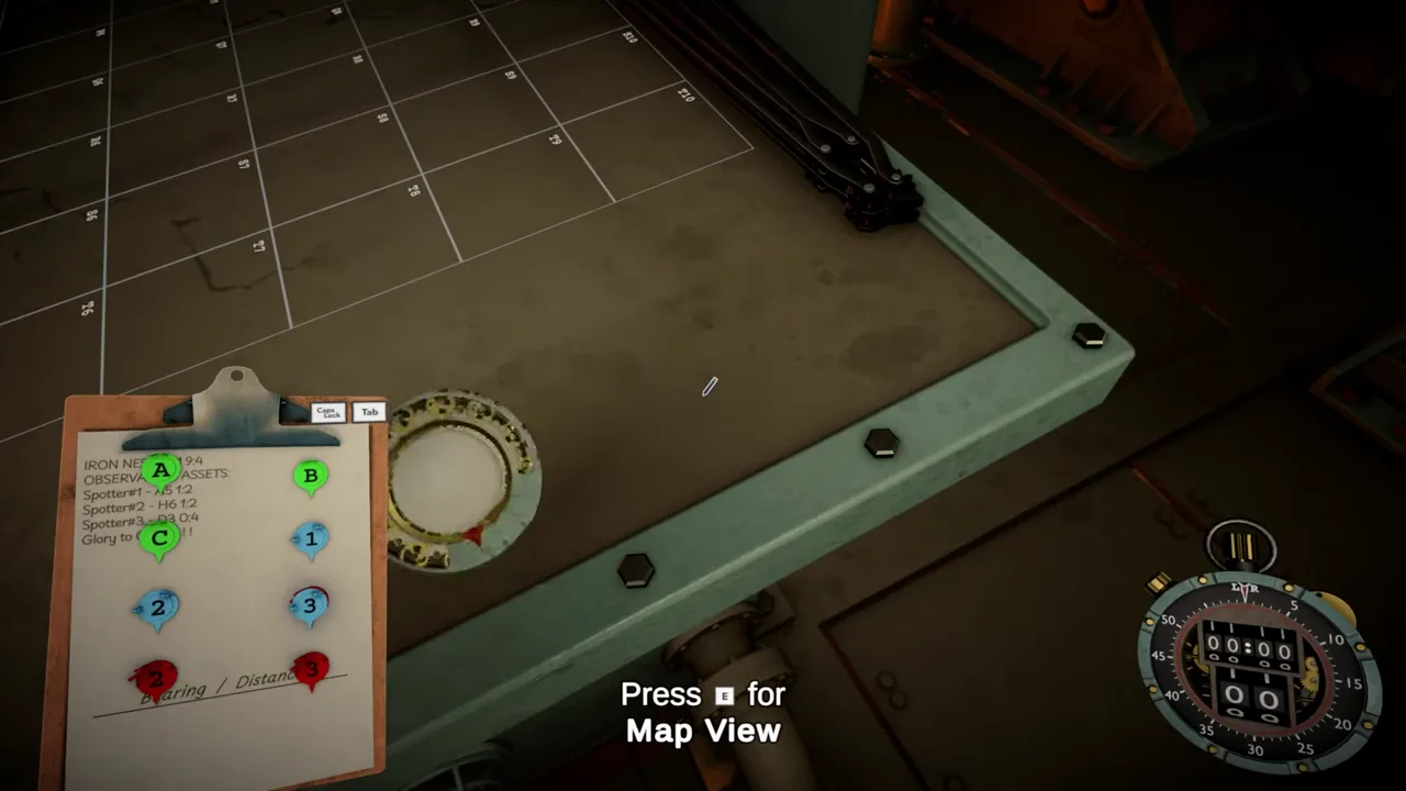
The official description says operators can move markers. Markers externalize information: observers, targets, friendly positions, candidate intersections and completed effects can remain visible without overloading memory.
Use consistent colors and labels. Separate confirmed points from candidates. Archive or remove abandoned lines so an old construction does not masquerade as a new target.
The page image shows several colored markers, a grid, a range instrument and a clipboard before the entire solution is drawn. It captures the map as a workspace in progress rather than a finished minimap.
Aerial photographs and scars
The official text says aerial photos reveal outcomes and that the map remains a window onto the battlefield. “You can move the markers, but the scars remain” frames consequences as both narrative and visual state.
Do not assume every crater changes terrain physics or that every photograph updates in real time. The sources confirm persistence as presentation and consequence, not a specific deformation algorithm.
Use photos to compare expected and actual impact location. Preserve the fired solution so a visible mark can be associated with one shell and set of inputs.
Map errors and calculator errors
The calculator cannot detect that the wrong point was measured. If range input is internally consistent but derived from a false intersection, the calculator can return a precise wrong elevation.
Before revisiting ballistics, validate source positions, ray directions, distance centers, candidate selection and current turret origin. Then remeasure range and bearing independently.
The miss troubleshooting guide orders these checks so downstream controls are not adjusted to compensate for an upstream map mistake.
A map handoff checklist
Before moving to the calculator, confirm:
- Every plotted constraint has a named source.
- The target point satisfies all available reports.
- Ambiguous intersections are labeled and resolved by evidence.
- The Iron Nest marker reflects its current position.
- Range is measured from the turret to the target.
- Bearing is recorded separately using the current convention.
- Target and objective labels match the teleprinter message.
- Old constructions cannot be confused with the active one.
This is the boundary between intelligence work and fire control.
The dependable conclusion
IRON NEST confirms an interactive tactical map used for measurements, battle planning, markers and viewing consequences through aerial evidence. Reports provide source-relative coordinates, bearings and distances; the map converts them into a target point, then measures range and bearing from the current turret position.
Treat the map as an evidence model, not a decorative minimap. Preserve provenance, resolve intersections explicitly, update the Iron Nest marker after movement, and hand two clean outputs to the next systems. No downstream precision can repair a target that was confidently plotted from the wrong origin.