Aerial Reconnaissance System
Post-shot evidence and battlefield observation
How IRON NEST uses aerial photographs to reveal outcomes, connect impacts to the tactical map and support disciplined correction without promising undocumented damage indicators.
A photograph reveals an outcome only when it can be tied to a known shot.
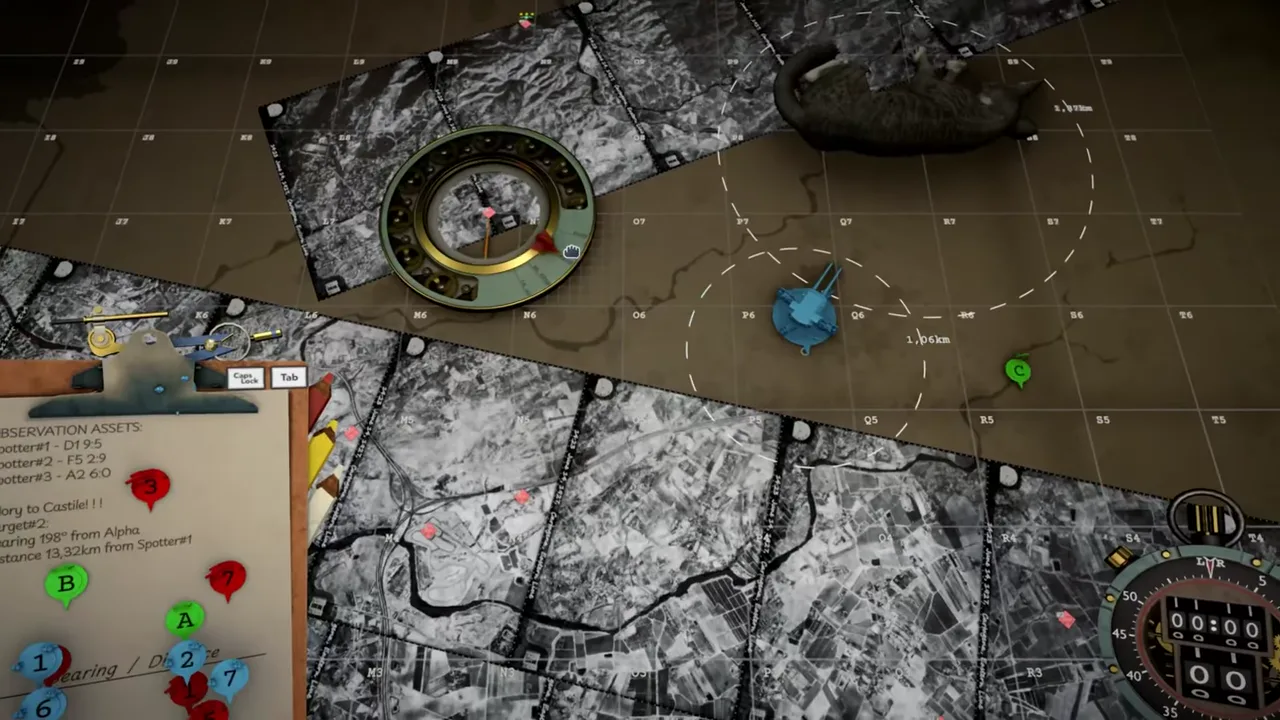
IRON NEST’s current official description says operators receive aerial photographs that reveal the outcome of their actions. Official launch footage places those black-and-white images directly around the tactical map, where observer markers, plotted lines and measuring tools already live. Reconnaissance is therefore not a separate cinematic reward; it returns battlefield evidence to the same workspace that produced the shot.
The official wording is deliberately broader than “shows exactly where every shell landed.” A photograph can reveal damage, terrain change, a target state or another consequence. This page documents how to use that evidence without inventing a universal hit marker, penetration icon or correction formula.
Evidence requires a known shot
A photograph becomes operationally useful when the operator can connect it to a recorded firing state. Preserve target identifier, shell label, charge, elevation, bearing, gun side, turret position and firing sequence.
Without that record, a new crater or plume may be visually impressive but diagnostically ambiguous. It could belong to another stage, another target or prior battlefield state. The official product text emphasizes that scars remain, which makes temporal comparison important.
Treat every photo as one piece of a versioned battlefield record, not as an isolated answer screen.
Aligning the photograph with the map
The official frame shows aerial imagery over and around the grid map. To compare expected and observed locations, identify common landmarks, grid boundaries or marked targets. Confirm orientation before describing an impact as left, right, short or long.
A photograph may be cropped, rotated or focused on a local area. The cited public sources do not publish a universal scale or north-up rule. Use the current interface’s overlays and labels rather than assuming ordinary map orientation.
If the image cannot be aligned confidently, record the uncertainty instead of applying a correction from a guessed direction.
Spatial error versus effect error
Separate two questions:
- Did the shell arrive at the intended location?
- Did the selected effect satisfy the objective?
A visible impact away from the target is primarily a spatial problem. Check target construction, range, bearing, shell-specific solution, charge, elevation and traverse. An impact at the intended point without objective progress may be an ammunition-purpose or mission-condition problem.
This separation prevents operators from changing shell type to compensate for a bad bearing or nudging elevation when the real issue is target effect.
Lateral corrections
If the photograph can be aligned and the impact is clearly left or right of the intended point, inspect map construction, bearing convention and turret traverse. Do not immediately change charge or elevation, which primarily affect the downrange solution.
Confirm the Iron Nest had not moved after the bearing was measured. Confirm the active target marker was not confused with an observer or candidate intersection. Then change one uncertain lateral input and preserve the new shot record.
The tactical map system defines the source-relative geometry that precedes traverse.
Short and long corrections
An impact aligned with the bearing but short or long points toward target range, shell type, charge, elevation or a mismatch between the calculator and physical gun.
First remeasure range from the current turret position. Then verify the calculator’s shell field, selected charge and required elevation. Finally, confirm those values were applied to the loaded gun.
Do not invent a fixed “add one mark” correction. The public sources do not publish correction increments, and different shells or charges can respond differently. Recalculate through the current system.
Reading damage without a fictional health bar
The official text says photos reveal outcomes and barrels reshape the landscape. It does not define a standardized visual language for destroyed, penetrated or neutralized targets.
Use objective updates, later reports and clearly changed structures together. A dark patch is not automatically a penetration. Smoke can obscure rather than prove destruction. A crater near a target can show location without proving the requested effect.
Where the current build provides explicit confirmation, record its wording and version. Otherwise describe only what the image visibly shows.
Persistent scars and before/after comparison
“You can move the markers, but the scars remain” suggests that battlefield change persists at least as part of the map’s narrative and visual record. Before/after comparison can reveal what changed between stages.
Keep the initial photo or mental baseline. After firing, compare roads, structures, terrain marks and target markers. If multiple shells were fired before a new image arrived, do not attribute each scar to a specific shot without additional evidence.
Persistence should not be inflated into a claim about permanent physics deformation across every mode. The official source confirms scars as meaningful presentation, not an engine specification.
Reconnaissance timing
The reviewed product text does not publish how quickly photographs arrive, whether the operator requests them manually, or whether every shot receives one. Mission scripting and mode may affect availability.
Do not build a universal timer from a single operation. If a current mission provides an expected arrival cue, preserve it with the verification date. Under counter-battery pressure, decide whether waiting for evidence is safer than acting on uncertain information.
The absence of a new photo is not automatically a system failure; it may be a stage condition.
Reconnaissance and moral evidence
The photographs do more than support ballistic correction. Official language connects them to the consequences of the operator’s actions. High Command can issue a directive in abstract language; the aerial image can return physical evidence of what that directive meant on the ground.
That does not prove every photo creates a branch or changes a newspaper. It establishes a narrative function: the machine gives the operator distance from the target, while reconnaissance partially closes that distance after the shot.
See operator and responsibility for the thematic structure.
A reconnaissance log
For each image, record:
- mission and stage;
- photo sequence or arrival time;
- target identifier and expected location;
- last known shot or shots;
- visible impact or change;
- alignment confidence;
- objective or report update;
- next correction and its reason.
This log prevents hindsight from rewriting the fired state and helps distinguish repeatable rules from one scripted event.
The one-variable correction rule
When the evidence supports a correction, change one uncertain component at a time. A lateral miss may justify a bearing correction. A short impact may justify remeasuring range or fixing charge–elevation mismatch. Do not redraw the target, swap shell and alter charge simultaneously.
The next photograph should test a hypothesis. If too many inputs change, it cannot reveal which hypothesis was correct.
The why firing solutions miss page provides the full diagnostic order.
What the sources do not establish
Current public sources do not prove:
- an image after every individual shot;
- exact photo delivery timing;
- standardized north, scale or crop across missions;
- automatic numerical correction suggestions;
- universal penetration or destruction markers;
- a direct mechanical link between every photo and newspaper report;
- identical reconnaissance behavior in campaign and challenge modes.
These are appropriate targets for build-level testing, not assumptions.
The dependable conclusion
Aerial photographs are a confirmed IRON NEST system for revealing outcomes. Official footage integrates them with the tactical map, supporting spatial comparison and a persistent record of battlefield consequences.
Their value depends on disciplined provenance. Preserve the fired state, align the image carefully, separate spatial error from effect error, change one variable at a time and use objective updates alongside visible evidence. Reconnaissance closes the loop only when the operator remembers exactly which loop produced the photograph.