Terrain, Scenery and Fire Control
Evidence-led terrain interpretation
How to use visible terrain as operational context in IRON NEST without inventing region-specific modifiers, shell rules or mission behavior that official sources do not confirm.
Scenery can frame a decision; only evidence can define a modifier.
Terrain is one of the easiest places for a game wiki to sound knowledgeable while becoming unreliable. A coast suggests long views. Mountains suggest angle. A city suggests collateral risk. An industrial skyline suggests hardened targets. Plains suggest mobility. These are intelligible associations from real geography and war fiction, but they are not automatically IRON NEST mechanics.
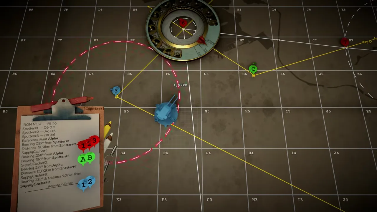
What current official sources confirm is a manual heavy-turret workflow: intelligence reports arrive through teleprinters, an interactive tactical map supports measurements and battle planning, the operator enters information into a ballistic process, and aerial photographs show outcomes. The released feature list also says the campaign spans 15 regions. It does not provide a published table that says a named region applies a wind model, elevation penalty, visibility rule, target-speed multiplier, ammunition bonus, armor category, or compulsory firing arc.
This page explains how to talk about terrain honestly while still making it useful for players. The goal is not to deny what a mission looks like. It is to distinguish visible context from a confirmed cause in the fire-control model.
Four layers of a terrain claim
Start by asking which layer a statement belongs to.
Presentation is what can be seen or read: a ridgeline in an aerial image, smoke over a settlement, trees near a target, a rail line, a dark industrial interior, a shoreline, weather, or a briefing’s descriptive language. Presentation can establish atmosphere and a local visual record.
Information is what the interface supplies: a map point, observer position, coordinate, range, bearing, task-card label, target marker, objective, or photo. This layer can directly participate in a firing solution when it is current and legible.
Mechanics are rules the game actually applies: an input field, a stated restriction, a repeatable consequence, or a developer-described system that remains valid for the released build. These deserve precise wording and a source.
Interpretation is advice drawn from the other layers: for example, “recheck the map after a position change” or “do not assign a visible bunker a shell type without reading the objective.” Interpretation can be helpful, but it should announce itself and never masquerade as an unpublished stat.
Most bad region pages begin with presentation, skip the information layer, and announce a mechanic. Keeping these layers separate fixes the chain.
What is actually relevant to a firing solution
The immediate fire-control problem is defined by source-relative intelligence and the turret’s current position. Plot the target from reports, measure range and bearing from the Iron Nest, choose the applicable shell or task-card state, apply charge and elevation through the game’s tools, set traverse, and verify outcome. The tactical map system and ballistic calculator reference explain those roles in detail.
Terrain can matter to this process when the game represents it through one of those inputs or outcomes. A mission might explicitly label an obstacle, state an environmental constraint, give a special target instruction, show a relevant height value, or reveal an effect in the map or aerial photo. In that case, quote or capture the specific evidence and limit the claim to the context in which it was observed.
Terrain does not matter merely because a player expects it to. A dramatic ridge in the background is not proof of a hidden elevation correction. A city-like map image is not proof that the game models civilian casualties or blast radius. A burning structure is not proof of an incendiary shell. A vehicle moving in a trailer is not proof of a regional mobility rule. The evidence has to bridge the gap.
A responsible mission observation method
When a mission appears visually distinctive, create a concise field note rather than a general rule. Record the displayed mission and location name, build version, mode, objective wording, current Iron Nest position, reports received, and visible map context. Then record the exact solution inputs and result.
If a result differs from expectation, change one variable at a time on a later comparable attempt where the game permits it. Did the target’s position change? Was the map range remeasured after moving the turret? Was a different shell state selected? Did the objective or report identify a special condition? Was the conclusion based only on an aerial photograph? This procedure produces evidence that another player can inspect.
Do not compress a one-off story event into a global rule. A scripted event can be narratively specific; a procedural objective may reuse an environment without preserving the same targets. A single successful shot can validate a mission outcome, but it rarely proves a universal penetration or cover formula.
Terrain and shell selection
Current official product text explicitly names armor-piercing rounds for breaching bunkers, smoke for screening friendly withdrawals, and phosgene gas in a censored action. Official pre-release footage also shows readable task-card labels including PGAS, TGAS, SMK, AP, STAR and HCHE. These are meaningful sources about ammunition identity and a few purposes.
They do not justify a terrain-specific ammunition doctrine. “Urban means smoke,” “industrial means AP,” “mountain means high explosive,” and “coast means illumination” may sound strategically tidy, but none is a published IRON NEST rule in the reviewed material. Select a shell from the current objective, its explicit target description, and the evidence tier of the ammunition itself. The ammunition evidence status page lists what each source actually supports.
This matters because a shell’s visible name can be stronger evidence than a landscape association. A bunker objective explicitly tied to AP is a more defensible basis for action than a player assumption that concrete-looking scenery demands a separate concrete-piercing round.
Terrain and consequence
The official description says aerial photographs reveal outcomes and that the map retains scars even when markers move. Those statements make battlefield consequence part of the presentation and feedback loop. They do not identify the simulation depth beneath every crater, destroyed object, or smoke plume.
Use aerial evidence to audit the shot you actually fired. Compare the observed mark or target state with the plotted point, objective, shell state and turret position. If the photo differs from the expected impact, diagnose the upstream chain before attributing the result to a terrain modifier. The why firing solutions miss guide provides that order: check target construction, range, current origin, shell, charge, elevation and traverse rather than inventing a hidden environmental penalty.
This approach is especially useful in a game about imperfect information. The right response to uncertain feedback is a better record, not a more confident story about the map.
Questions worth testing after launch
The released game may contain regional or environmental behavior that the public listings do not enumerate. These are productive questions for current-build research:
- Does any mission display a named terrain condition that changes an input or outcome?
- Are elevation or visibility values shown directly on the tactical map?
- Do target types or briefing instructions vary predictably by an explicitly named location?
- Does movement change the map position in a way that requires a new solution?
- Are observed scars cosmetic, objective feedback, or a persistent tactical state?
- Does a challenge or story mode specify location-linked restrictions?
Each answer should include the exact mode, build, label, before-and-after state, and repeatability. Negative findings are useful too: “no published modifier seen in these sources” is safer and more informative than an invented table.
The dependable conclusion
Terrain in IRON NEST is real as setting, visual context and possible mission evidence. The confirmed fire-control workflow runs through reports, a map, measurement, shell state, charge, elevation, traverse and outcome review. The reviewed official material does not publish a universal regional terrain-modifier system.
Describe what a mission visibly shows. Record what the interface and objective explicitly require. Test repeatable behavior before naming it a mechanic. That keeps regional writing vivid enough to orient a player and disciplined enough not to turn a picturesque backdrop into false ballistic advice.